A raw NOTAM typically looks like this:
A) KJFK/20250610/001 A 1
B) 2506101200 2506101800
Q) KJFK/QMRLC/IV/NBO/A/000/999/4038N07346W005
E) RWY 09L CLOSED FOR RESURFACING AND EQUIPMENT ON RUNWAY
This tells a pilot or dispatcher everything they need to know about a runway closure at JFK Airport in about four lines.
The format is undeniably arcane. The NOTAM system was standardised in the late 1940s, when aeronautical information was optimised for density of meaning rather than richness of information because it was transmitted via teleprinter - machines where every character had a cost and communication speeed was around a hundred and words per minute. These constraints disappeared decades ago - but the format lives on in the world of airspace hazard notifications.
For broader context on what NOTAMs are, where they came from, and how space launches are straining the system, read the companion article: Understanding NOTAMs: From Teleprinters to Digital Airspace. For an FAA training reference on ICAO NOTAM format, see the FAA’s ICAO NOTAM 101 presentation for airport operators.
NOTAM lifecycle: new, replacement, cancellation
The header does more than identify the NOTAM number. It also tells you whether the notice is new, replacing an earlier notice, or cancelling one:
NOTAMN= New NOTAMNOTAMR= Replacement NOTAMNOTAMC= Cancellation NOTAM
For example:
A0954/26 NOTAMC A0804/26This means A0954/26 is a cancellation NOTAM, and it cancels the earlier NOTAM A0804/26.
A replacement is different from a cancellation. NOTAMR means the earlier NOTAM is superseded by a new version. The activity or condition may still exist, but the details have changed. NOTAMC means the earlier NOTAM is cancelled. The previous notice is no longer valid.
A cancellation NOTAM often includes enough detail from the original NOTAM to identify what is being cancelled. It may repeat the affected airspace, route, or activity description, then end with CANCELED. That does not mean the restriction remains active. It means the referenced previous NOTAM is being cancelled.
The first line: series, number, and action
Many ICAO-formatted NOTAMs begin with a header line before the lettered fields:
A1429/26 NOTAMNThe first character, A, is the NOTAM series. It is not universally “the type” of NOTAM. Series letters such as A or B are used to organise and sequence NOTAMs within an issuing or accountability context. In one FAA training example, B is used for movement-area NOTAMs, but that is an example of series organisation, not a global rule that B always means movement area.
The digits after the series letter are the NOTAM number within that series. In A1429/26, 1429 is the sequence number and 26 is the year. Numbering restarts each year within the relevant series and issuing/accountability context.
That context matters. These are not necessarily the same NOTAM:
A1429/26 - ZJX / KZJX
A1429/26 - ZHU / KZHU
The visible number is the same, but the accountability or location context is different. FAA guidance describes international NOTAMs as being numbered by accountability, location, and series, so a system should not treat A1429/26 alone as a globally unique identifier.
The action code after the number tells you where the notice sits in its lifecycle: NOTAMN for a new NOTAM, NOTAMR for a replacement, and NOTAMC for a cancellation.
The A line: who issued it and what kind
A) KJFK/20250610/001 A 1The A line identifies the notice itself. It tells you three things.
Who issued it. The four-letter ICAO code identifies the issuing Flight Information Region (FIR). KJFK means New York, but FIR codes don’t always match airport codes. EGLL is London, LFPG is Paris, YMML is Melbourne. FIR codes identify the authority responsible for the airspace, not necessarily the airport the NOTAM concerns.
Its sequence number. 20250610/001 is the issue date and sequence number within that FIR - the first NOTAM issued by this authority on June 10, 2025.
The type and issue status. A single letter indicates scope: A = airfield (local), E = en-route (within a FIR), W = widespread (multiple FIRs or large area). Space launches typically use W. The trailing number indicates whether it’s a new notice (1), a replacement (R), or a cancellation (C).
The B line: when it’s valid
B) 2506101200 2506101800The B line is two timestamps in UTC: the start and end of the valid period. The format is YYMMDDHHMM. So 2506101200 means 2025, June 10, 12:00 UTC. 2506101800 is 18:00 UTC the same day - a six-hour window.
For dispatchers and pilots, the B line is often the first check: does this NOTAM overlap with my flight’s timing? A closure that ends at 10:00 UTC doesn’t affect a 14:00 departure.
Space launch NOTAMs complicate this. The window is often expressed as a broad range - “valid 1400 to 1800 UTC” - but the actual launch might happen at any point within it, or slip entirely. The traditional NOTAM format assumes fixed start and end times. It handles probabilistic timing poorly, which is one reason why launch-related NOTAMs get updated many times in the hours before a mission.
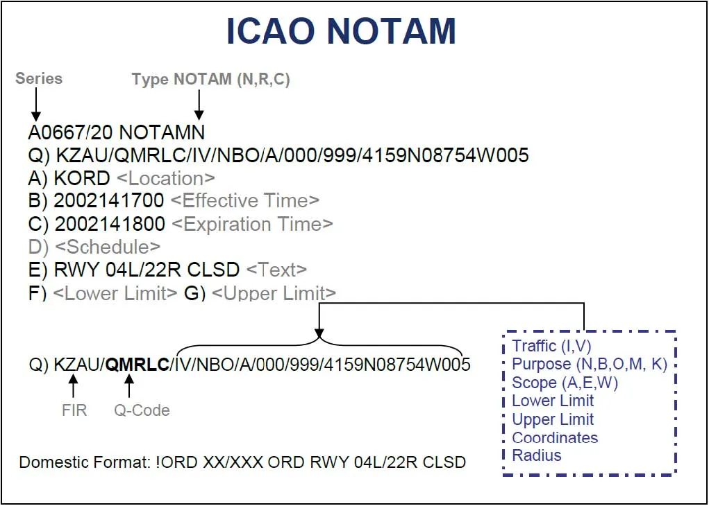
The Q line: the encoded core
Q) KJFK/QMRLC/IV/NBO/A/000/999/4038N07346W005The Q line is the most information-dense part of a NOTAM. It packs ten slash-separated fields into one line, each systematically decodable.
| Field | Value | Meaning |
|---|---|---|
| 1 - FIR | KJFK | The Flight Information Region responsible - New York |
| 2 - NOTAM code | QMRLC | Q = prefix; MR = Movement area/Runway; LC = Closed |
| 3 - Traffic type | IV | Affects both IFR (instrument) and VFR (visual) traffic |
| 4 - Purpose | NBO | Navigation, Be careful, Operational - multiple categories |
| 5 - Scope | A | Aerodrome - affects the immediate airport area only |
| 6 - Lower limit | 000 | From ground level |
| 7 - Upper limit | 999 | To unlimited altitude |
| 8-9 - Centre point | 4038N07346W | 40°38’N, 73°46’W - centre of JFK Airport |
| 10 - Radius | 005 | 5 nautical miles from the centre point |
The NOTAM code (Field 2) in detail
The five-character NOTAM code in field 2 is the most important part of the Q line. It always starts with Q, followed by two subject characters (what is affected), followed by two status characters (what is happening to it).
| Code | Subject | Status | Meaning |
|---|---|---|---|
QMRLC | MR - Movement/Runway | LC - Closed | Runway closed |
QWRAS | WR - Airway/Route | AS - Area restricted | Route or airway restricted |
QNNAS | NN - Navaid | AS - Unserviceable | Navigation aid offline |
QLCAS | LC - Centerline lighting | AS - Unserviceable | Runway centerline lights out |
QORAE | OR - Obstacle | AE - Erected | New obstacle (tower, crane) erected |
These codes are standardised by ICAO across all 192 member states. A pilot anywhere in the world reading QMRLC knows it means a runway closure - regardless of the language in the E line below.
The E line: what it means in plain language
E) RWY 09L CLOSED FOR RESURFACING AND EQUIPMENT ON RUNWAYThe E line is the free-text field - the only part of a NOTAM intended to be read directly by a human without decoding. It explains the situation in plain language.
Or it should. In practice, E lines vary considerably. Some are clear and detailed. Others use abbreviations almost as dense as the Q codes: “RWY 09L LC DUE SFC REPR EQP ON RWY” communicates the same thing but demands translation. Recent ICAO Annex 15 amendments are pushing for full sentences and plain English in E lines, with the FAA’s NOTAM modernisation initiative making this a priority in the US. Adoption across the global network is uneven.
Example cancellation NOTAM
Cancellation NOTAMs are easiest to understand if you read the header first and the E line second:
A0352/26 NOTAMC A0272/26
Q) KZBW/QWEXX////005/010/4324N06927W005
A) KZBW
B) 2605071341
E) AIRSPACE LOW FLYING MIL OPS ... CANCELED
Walking through it:
A0352/26is the cancellation noticeNOTAMCmeans cancellationA0272/26is the prior NOTAM being cancelledB) 2605071341is when the cancellation became effective: 7 May 2026 at 13:41 UTC- The
E)field repeats the activity being cancelled, then statesCANCELED
The important operational reading is that the old low-flying military operations notice is no longer valid. The repeated subject text is there to identify the cancelled activity, not to keep the activity active.
Reading a complete example: a space launch NOTAM
Runway closures are straightforward. Space launch NOTAMs show the format under more stress. Here is a full example:
A) KZJX/20250627/001 W 1
B) 2506271400 2506271900
Q) KZJX/QWRAS/IV/M/W/000/450/2823N08036W100
E) ALTRV FOR SPACE LAUNCH FROM CAPE CANAVERAL FL.
   AIRSPACE CLOSED SFC-FL450 WITHIN APPROX 100NM RADIUS
   28 DEG 23 MIN N / 080 DEG 36 MIN W.
   LAUNCH WINDOW 1445Z-1545Z. WINDOW MAY SLIP.
   EXPECT UPDATES EVERY 6 HOURS. MONITOR FOR CHANGES.
Walking through it:
- A line: Jacksonville FIR (
KZJX), widespread scope (W), first issue - B line: Valid 14:00 to 19:00 UTC on 27 June - a 5-hour window, larger than the 1-hour launch window to buffer for slippage
- Q line: Airway/Route Restricted (
QWRAS), affects all traffic, widespread scope (W), surface to FL450, centred on Cape Canaveral, 100nm radius - E line: Altitude Reservation for a space launch, 100nm closure, launch window 14:45-15:45Z, may slip, updates every 6 hours
A dispatcher reading this knows immediately that every southbound or coastward flight from the northeastern US during that five-hour window needs to be assessed. Any routing that crosses the 100nm circle around Cape Canaveral at any altitude below FL450 is affected. The launch window might slip, so the five-hour NOTAM is a buffer - the actual restriction could clear sooner, or could extend if the launch scrubs and reschedules.
For space operations, the E), F), and G) fields are especially important when they appear separately. A debris-return NOTAM might include:
E) TEMPO DANGER AREA ... ACTIVITY: SPACE DEBRIS RETURN
F) SFC
G) UNL
This means a temporary danger area has been established for space debris return. F) SFC means the lower vertical limit is the surface. G) UNL means the upper vertical limit is unlimited. Coordinate lists in the E) field usually define the lateral boundary polygon.
Common Q codes quick reference
| Code | Meaning | Typical impact |
|---|---|---|
QMRLC | Runway closed | High - route and approach replanning |
QWRAS | Airway/route area restricted | High - rerouting required |
QNNAS | Navigation aid unserviceable | Variable - depends on navaid criticality |
QLCAS | Centerline lighting unserviceable | Moderate - night/low-vis operations only |
QORAE | Obstacle erected | Variable - depends on location and height |
QIIA | General information notice | Low - often administrative |
QAREA | Area restriction (generic) | High if on routing, nil if not |
The bigger picture
Once you know the structure, a single NOTAM becomes readable. The harder operational problem is volume, prioritisation, and constant change across the wider system.
Operational systems should not treat a NOTAM number as a static one-time fact. NOTAMs have a lifecycle: a mission or airspace restriction may have an original notice, one or more replacements, and eventually a cancellation. Systems should track the latest state and preserve prior revisions where possible.
There is also a data-access caveat. Some NOTAM APIs and briefing systems primarily return active NOTAMs. Searching a past effective date range does not always mean historical inactive NOTAMs will be returned. In the FAA NMS API documentation, most filters are described as filtering active NOTAM data. Cancelled or inactive NOTAMs may only be available through specific identifiers or recent update feeds.
For a deeper look at the history of the NOTAM system, why space launches are putting it under strain, and what digital modernisation looks like, read: Understanding NOTAMs: From Teleprinters to Digital Airspace.